The Visayas and Mindanao Region is under Storm Signals as Tropical Depression Wilma made a landfall. According to the latest weather bulletin released by PAGASA, Bagyong Wilma weakened into a Low Pressure Area.
The latest weather bulletin was released by the weather bureau at around 5:00 PM on November 4, 2013. The location of eye/center of the Low Pressure Area (LPA) as of 2:00 PM was estimated based on all available data at 32 km Southeast of Tagbilaran City, Bohol ((9.5°N, 124.1°E).
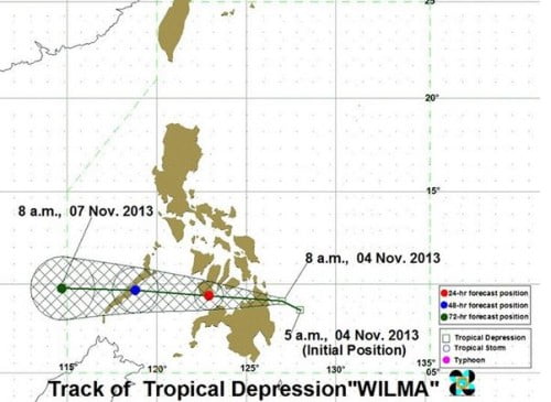
The LPA embedded along the InterTropical Convergenze Zone (ITCZ) affecting the Visayas and Mindanao areas. The Tropical Depression Wilma made landfall in the Philippines over Tandag City, Surigao del Sur around Monday noon.
According to PAGASA’s forecast the tropical depression which slows down as an LPA is expected to be 440 kilometers west of Puerto Princesa City or outside the Philippine Area of Responsibility by Thursday morning.
Meanwhile here’s the previous Storm Signals Raised by PAGASA:
Visayas
- Southern part of Negros Occidental
- Southern part of Negros Oriental
- Southern Cebu
- Siquijor
- Bohol
- Southern Leyte
Mindanao
- Dinagat Island
- Surigao Del Norte
- Siargao Island
- Surigao Del Sur
- Agusan Del Norte
- Agusan Del Sur
- Misamis Oriental
- Misamis Occidental
- Camiguin Island
- Northern part of Zamboanga Del Norte
For the complete PAGASA Weather Bulletin issued at around 4:00 PM click here.