PAGASA Releases Latest Weather Update for Thursday (July 15)
The state weather bureau PAGASA reported that the low-pressure area and habagat would bring cloudy and scattered rains over some parts of the country.
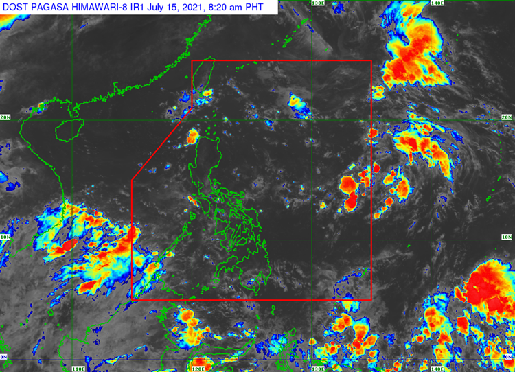
On Thursday (July 15, 2021), the Philippine Atmospheric, Geophysical and Astronomical Services Administration released the latest weather update in the country. The low-pressure area and southwest monsoon would continue to affect the country’s weather condition.
PAGASA said that the low-pressure area spotted 1,600 kilometers east of Central Luzon. It has a slim chance of intensifying into a tropical cyclone. It is expected to move towards the northern part of Luzon.
The southwest monsoon would bring cloudy weather condition with scattered rainshowers and thunderstorms Western Visayas, Occidental Mindoro and Palawan including Kalayaan Islands.
The localized thunderstorms would bring partly cloudy to cloudy condition with isolated rainshowers or thunderstorms over Western Visayas, Zamboanga Peninsula, Palawan, Mindoro provinces and the rest of Visayas.
Metro Manila and the remaining parts of the country would experience similar weather conditions but possible flash floods or landslides during severe thunderstorms are expected.
Read Also: PAGASA Says Fair Weather Expected Over Eastern Part of PH
Meanwhile, the coastal water conditions over the entire country would be slight to moderate, according to the weather agency.
What can you say about the latest weather update? Just feel free to leave your comments and reactions to this article.
Read Also: PAGASA Says LPA To Bring Cloudy Conditions & Scattered Rains Over Parts of PH