PAGASA Releases Latest Weather Update for Friday (October 9)
PAGASA – The state weather bureau reported that a low-pressure area and the ‘habagat’ are expected to bring rains over some parts of the country.
On Friday (October 9, 2020), the Philippine Atmospheric, Geophysical and Astronomical Services Administration released the latest weather updates in the country. The LPA and southwest monsoon would continue to affect the country’s weather condition.
PAGASA said that the low-pressure area was last spotted at 310 kilometers west northwest of Coron, Palawan. The southwest monsoon threatens to bring possible flash floods and landslides over Southern Luzon, Visayas, and Mindanao during severe thunderstorms.
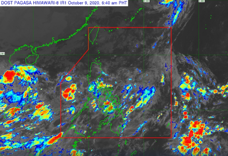
The LPA would bring cloudy weather conditions with scattered rainshowers and thunderstorms over Metro Manila, Central Luzon, CALABARZON, MIMAROPA, Bicol Region, Visayas, Zamboanga Peninsula, Northern Mindanao, and Caraga.
The northeasterly surface Windflow would also bring partly cloudy conditions with isolated light rains over Ilocos Region, Cordillera Administrative Region, and Cagayan Valley.
Meanwhile the coastal water conditions over northern Luzon while Metro Manila, Central Luzon, and CALABARZON would have moderate to rough surrounding sea conditions.
Slight to moderate coastal waters are also expected over the remaining parts of the country, according to the weather agency.
What can you say about the recent weather update? Just feel free to leave your comments and reactions to this article.
Read Also: PAGASA – Latest Weather Updates This October 8, 2020