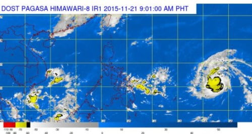
The country’s weather bureau, Philippine Atmospheric, Geophysical and Astronomical Services Administration (PAGASA) warned the Filipino public that the severe Tropical Storm with international name “In-Fa” has high chance to enter the Philippine Area of Responsibility (PAR) on Sunday or Monday.
Based upon the latest weather bulletin released by PAGASA, the tropica storm In-Fa was spotted at 2,510 km. East of Mindanao with maximu sustained winds of 130 kph near the center and gustinees of up to 160 kph. It is forecast to move West Northwest at 20 kph.
Once the tropical storm will enter PAR, the weather bureau told the media that it will be named as Bagyong “Marilyn,” the 13th tropical cyclone to affect the Philippines this year.
Although Bagyong Marilyn is expected to enter the Philippine Area of Responsibility, it has a slim chance to make a landfall and is expected to change its direction from west northwest to east northeast due to presence of ridge high pressure area (HPA).
Once Bagyong Marilyn enters PAR, it will bring rains over the Eastern section of the country due to its extended cloudiness but right now the storm is still too far to affect the country.

