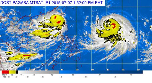
The country’s weather bureau, Philippine Atmospheric Geophysical and Astronomical Services Administration (PAGASA) announced the lifting of signals for Bagyong Egay, which already moved out the Philippine area of responsibility (PAR) on Tuesday morning. Bagyong Egay was spotted 320 kilometers West Southwest of Basco, Batanes, at around 8:00 AM today.
PAGASA noted that the areas of Northern Luzon was most affected with the latest weather disturbance affecting the country. Although Bagyong Egay already moved out of PAR, PAGASA still warned of possible flashfloods and landslides due to “habagat” or southwest monsoon.
Aside from Bagyong Egay, PAGASA also expected another typhoon to enter PAR by Tuesday, it will be named as Bagyong Falcon, (international name Typhoon Chan-hom).
According to the country’s weather bureau, Bagyong Falcon was last seen 1,700 kilometers east of Luzon and moved west northwest at 20 kilometers per hour.
The stronger typhoon is packed with maximum sustained winds of 120 kph and gusts of up to 150 kph, but PAGASA’s Samuel Duran said that Bagyong Falcon could still intensify into a supertyphoon.