The latest weather disturbance that currently affecting the Philippines, Bagyong Egay (international name: Linfa) continued its track toward Northern Luzon but at a faster pace, as reported by the country’s weather bureau, PAGASA.
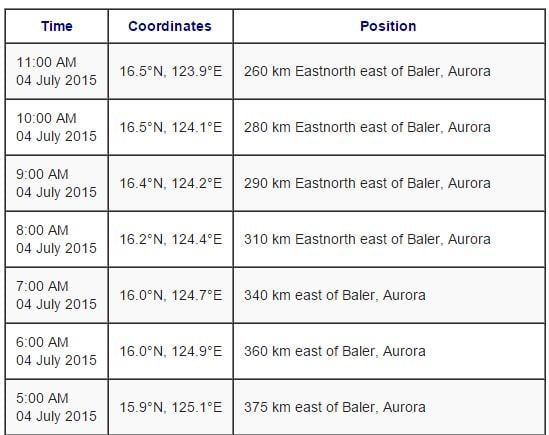
PAGASA stated that as of 10 AM today, Jly 4, 2015, Bagyong Egay was moving northwest at a speed of 13 kilometers per hour. Bagyong Egay was last spotted 280 kilometers east of Baler, Quezon Province.
Bagyong Egay packs maximum sustained winds of 85 kph and gustiness of up to 100 kph. The weather bureau also released the updated Public Storm Warning Signals in different parts of the Philippines.
Public Storm Warning Signal No. 2: Isabela, Quirino, Cagayan and Northern Aurora
Public Storm Warning Signal No. 1: The rest of Aurora, Nueva Ecija, Nueva Vizcaya, Ifugao, Benguet, Mt. Province, Kalinga, Apayao, Abra, Ilocos Norte, Ilocos Sur, Babuyan and Calayan Group of Islands.
According to PAGASA’s latest weather bulletin, they expected that Bagyong Egay will make a landfall at the northeastern part of Cagayan on Sunday morning or afternoon.
The areas of Metro Manila and the regions of Bicol, Calabarzon and Mimaropa will experience moderate to occasionally heavy rains and thunderstorms because of “habagat” (southwest monsoon).
Here’s the Hourly Update of Bagyong Egay: