The Philippine Atmospheric, Geophysical and Astronomical Services Administration forecasts that Bagyong Mario (Tropical Storm Mario) has intensified as it continues to move over the Philippine Sea. Bagyong Mario’s international code name according according to Japan Meteorological Agency is Typhoon Fong-wong.
See Also: Bagyong Mario September 19, 2014 Storm Signals & Updates

Based upon the weather bulletin issued at around 5:00 AM on Thursday, September 18, 2014, “Bagyong Mario” was last spotted at 460 kilometers east of Catarman, Northern Samar with maximum sustaine winds of 65 kilometers per hour and gustiness of up to 80 kilometers per hour, as of 4:00 AM of September 18.
See Also: PAGASA Released Public Storm Warning Signals in Luzon
Bagyong Mario is forecast to move west northwest at 28 kilometers per hour. According to PAGASA, the Bicol Region and Eastern Visayas will experience moderate to heavy rains and thunderstorms which may trigger flashfloods and landslides.
As of press time, PAGASA noted that there is no storm signals in various parts of the country as Tropical Storm Mario continue to intensify. Based upon the typhoon track of Bagyong Mario it is forecasts to hit Casiguran, Aurora, Basco and Itbayat Batanes.
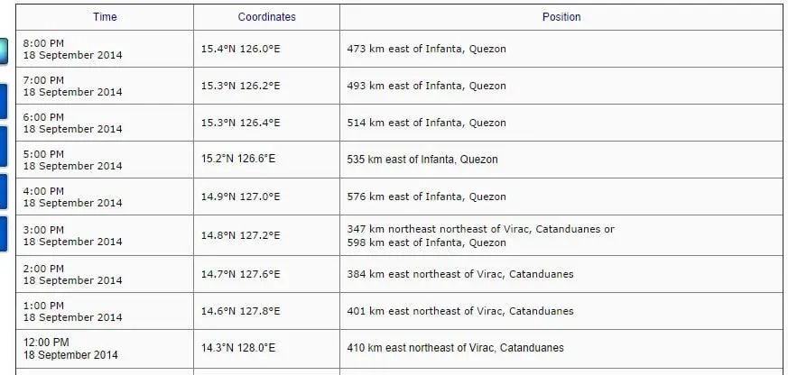
PAGASA forecasts that by Thursday evening, September 18, 2014, Bagyong Mario is estimated to be at 420 km East of Casiguran, Aurora, on Friday evening it will be 460 km Northeast of Basco, Batanes, and by Saturday evening, Bagyong Mario is forecasts to be at 810 km Northeast of Itbayat, Batanes or outside the Philippine Area of Responsibility (PAR).
The weather bureau also noted that Metro Manila and the rest of Luzon, the rest of Visayas and the regions of Zamboanga Peninsula, Northern Mindanao and CARAGA will have cloudy skies with light to moderate rains and thunderstorms.
Here’s the typhoon track of Bagyong Mario:
