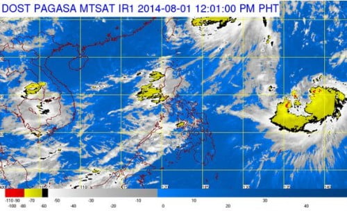
The country’s weather bureau, PAGASA, forecast that Bagyong Juan with an international name Halong, is set to enter the Philippine Area of Responsibility (PAR) next week. The tropical storm was last observed to be at 1,740 kilometers east of Central Luzon and it expected to enter the country on Monday or Tuesday.
The Bagyong Juan or Halong is forecast to follow the track of typhoon Florita, or Inday. The tropical storm Halong might intensify while it remained over water. International weather bureau noted that Halong is currently packed a maximum sustained winds of 85 kilometers per hour and gusts of up to 100 kph.
Due to the upcoming storm to hit the Philippines, PAGASA, noted that the southwest monsoon continues to bring rains in Luzon and some parts of the Visayas region on Friday, July 1, 2014.
According to PAGASA, the provinces of Zambales, Bataan will experience monsoon rains while Metro Manila, the rest of Central Luzon and the regions of Ilocos, Calabarzon, Mimaropa, Bicol and Western Visayas will experience occasional rains.
The rest of the Philippines will experience partly cloudy to cloudy with isolated rains or thunderstorms, PAGASA noted. A moderate and strong winds blowing from the southwest would prevail throughout the entire archipelago and that the coastal waters would be moderate to rough.

