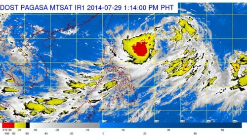
The Philippines weather bureau, PAGASA noted on their latest weather bulletin on Tuesday, July 29, that the Low Pressure Area (LPA) spotted east of Northern Philippines has intensified into a Tropical Depression. PAGASA stated that the tropical depression will be locally named as “Bagyong Inday.”
See Also: Bagyong Inday July 31 Updates
Although Bagyong Inday is not expected to make a landfall in the Philippines as confirmed by PAGASA forecaster Aldczar Aurelio, the tropical depression is already spotted at 870 kilometers east of Aparri, Cagayan as of 10:00 AM.
Bagyong Inday was packing with 55 kilometers per hour, moving northwest at 15 kph. Based upon the current movement of Bagyong Inday, PAGASA forecasts that the tropical depression will leave the Philippine Area of Responsibility on Thursday, July 31, 2014.
The newest tropical depression that enters the Philippines is expected to head towards the vicinity of our neighboring country, Japan. Aside from the Tropical Depression warning given by PAGASA, the agency also made an estimate with the country’s rainfall amount which will be at 7.5-15 millimeters per hour.
According the 24-hour forecast released on Tuesday, July 29, 2014, PAGASA noted that the ares of Metro Manila, Calabarzon, Mimaropa, Bicol Region, Western Visayas and the provinces of Zambales and Bataan will experience occasional rains.
Note: We will update this post for hourly report of Bagyong Inday.

