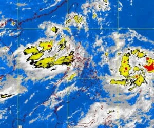
The heavy rains being experienced through out the country is due to the Tropical Storm Falcon who is getting stronger as it p(–foul word(s) removed–) the country due to the low pressure area seen near Catanduanes that merges to it.
PAGASA, the weather bureau that monitors the weather in the country has raised public storm warnings in some areas in the country including public signal number 1 in Aurora, Quezon, Albay, Camarines Norte and Sur, Catanduanes, Batanes, Isabela and Calayan group of Islands.
Affected areas are being warned by the government and weather officials to take precautionary measures and keep track to the latest update regarding typhoon Falcon especially those living in mountain parts and low lying areas to watch out for possible flashflood and landslide.
On the latest track of PAGASA, typhoon Falcon is moving towards northwest of the country at 15 Kilometer per hour with a maximum wind of 75kph and gustiness of up to 90kph.
The Low Pressure area that has been contributing to typhoon Falcon’s intensity has been spotted 550 km northeast of Catanduanes.
Due to the LPA, Falcon is moving slowly and is expected to be out of the country on Sunday morning, longer than what has been expected which is on Saturday.
One of the officials of PAGASA said that the merging of the two will surely bring heavy rains in the country particularly in Luzon where the tropical storm Falcon and the LPA is nearly located.
On the latest update, Typhoon Falcon has already caused big damaged in the country and has taken number of lives. Some of the international and domestic flights in the country have also been cancelled for safety measures of the p(–foul word(s) removed–)enger.